You are using an outdated browser. Please upgrade your browser to improve your experience.

The Best Topographic Maps

Planning your next outdoor adventure? Need to know how steep of a climb that hiking trail is going to take you? Then check out these apps for the best topo maps for iOS.

Cairn: The Trail Safety App
Topo Maps US
Maps 3D PRO - Hike & Bike

Best Apps

Highest scored apps in the category

Cairn: The Trail Safety App

Cairn: The Trail Safety App

FitClimb LLC

Cairn helps you stay safe on your hikes, runs and outdoor adventures

Cairn helps you stay safe on your hikes, runs and outdoor adventures. Easily share your plans with loved ones, find spots with cell coverage, download offline topo maps, see stats on your route, and record your hiking trail.

Named one of the three best map apps for navigating the wilderness by Outside Magazine.

GET FOUND IF YOU’RE OVERDUE
• Notifications: Safety contacts are...

Topo Maps US
Topo Maps US

Topo Maps US

David Crawshay

Download and view topographic maps covering the United States

Download and view topographic maps covering the United States.

Topographic maps are useful for recreational activities such as hiking, canoeing, camping, fishing, mountain biking, geocaching, and exploring.

MAPS
Choose from 2 map sources: USGS standard topographic or USGS hybrid topographic.

OFFLINE
Download maps for areas of interest to view them later when you don't have Internet access or you don't want to use cell data.

TRACKING
Use...

Maps 3D PRO - Hike & Bike

Maps 3D PRO

movingworld GmbH

Enjoy exploring the great outdoors

Enjoy exploring the great outdoors? If you’re a fan of biking, hiking and running then Maps 3D is the ideal app designed for planning your outdoor adventures. Whereas other mapping apps are primarily designed for cities and roads, displaying hills and mountains as flat and lifeless features, Maps 3D is packed with amazing features that brings the great outdoors to...

Also Good

Apps with average score

Scenic Map Eastern USA

Scenic Map Eastern USA

GrangerFX

A 3D topo map of the Eastern USA. The vector map data is contained within the app and can be used without an internet connection. Use it in a car, a boat, a plane or while hiking. It is like having more than a third of the country in your...

Scenic Map Grand Canyon

Scenic Map Grand Canyon

GrangerFX

Explore the rich landscapes around the Grand Canyon and Arizona while you discover Scenic Map, the best 3D topo map for the iPad and iPhone. The vector map data is contained within the app and can be used without an internet connection. Use it in a car, a boat, a...

Scenic Map Central USA

Scenic Map Central USA

GrangerFX

A 3D topo map of the Central USA. The vector map data is contained within the app and can be used without an internet connection. Use it in a car, a boat, a plane or while hiking. It is like having more than a third of the country in your...

Route Scout - GPS Topo Mapper

Route Scout - GPS Topo Mapper

Joseph Bartels

Record outdoor activities: designed for hiking

Features
Topographic map, waypoints, mileage, elevation, speed, time, moving average, breaks. Audio options for splits, nearby waypoints and off trail alerts.

Direct GPX import. Last imported route auto sets to "Follow". Offline topo maps specific to the route load for navigation.

Optional
Contributing members may import/save from HAZ &...

Scenic Map Alaska
Scenic Map Alaska
Scenic Map Alaska

Scenic Map Alaska

GrangerFX

A 3D topo map of State of Alaska, USA. The vector map data is contained within the app and can be used without an internet connection. Use it in a car, a boat, a plane or while hiking. It is like having the entire state in your pocket.

Scenic Map now...

Topo Maps Canada
Topo Maps Canada
Topo Maps Canada

Topo Maps Canada

David Crawshay

Download and view topographic maps covering Canada.

Topographic maps are useful for recreational activities such as hiking, canoeing, camping, fishing, mountain biking, geocaching, and exploring.

MAPS
Choose from 3 map sources: Canada Base Map (shaded/unshaded), and Toporama.

OFFLINE
Download maps for areas of interest to view them later when you don't have Internet access or...

Wikiloc Outdoor Navigation GPS

Wikiloc Outdoor Navigation GPS

Wikiloc Outdoor SL

Discover millions of outdoor trails around the world. Choose between hiking, running, bike, MTB, kayak, ski or up to 80 different types of activities.

Record your own routes on a map, add waypoints, take pictures along the itinerary and upload them to your Wikiloc account from your phone.

Enjoy free offline topographic...

Peakbagger
Peakbagger
Peakbagger

Peakbagger

Andrew Kirmse

Bring the mountains with you wherever you go!

* Search the huge database of mountains and trip reports from Peakbagger.com and ListsOfJohn.com
* Keep track of your climbs, even when offline
* Measure your progress against hundreds of peak lists
* Get route information and directions from SummitPost and ListsofJohn.com
* Find peaks near...

Topo Maps+
Topo Maps+
Topo Maps+

Topo Maps+

Glacier Peak Studios LLC

Designed and tested on real dirt, Topo Maps+ is packed with the maps & tools to plan and execute your backcountry adventure.

‣‣ MAPS FOR EVERY ACTIVITY
‣Setup your map based on your planned activity

‣‣ PLANNING TOOLS
‣ Compare and Download maps for use offline.
‣ Combine overlays to customize your map view
‣ Smart...

You Need A Map
You Need A Map
You Need A Map

You Need A Map

GrangerFX

If you get lost or in an emergency, YOU NEED A MAP! A map that covers the entire USA, all 50 states. A map that works everywhere even without a cell phone signal. A map that shows not just roads but also terrain, streams, lakes and other landmarks.

Note: If...

Scenic Map Western USA

Scenic Map Western USA

GrangerFX

A 3D topo map of the Western USA and Hawaii. The vector map data is contained within the app and can be used without an internet connection. Use it in a car, a boat, a plane or while hiking. It is like having more than a third of the country...

Terra Map - Trail Explorer

Terra Map - Trail Explorer

GEC s.r.l.

Enjoy every adventure safely with the best technology for outdoor navigation.
Developed with the help of experienced hikers and bikers, Terra Map can meet all your needs.

►► FEATURES:
• Optimized for use on both iPhone and iPad
• Incredibly accurate and easy-to-read worldwide maps
• Maps download for offline usage
• Weather forecasts for any...

NP Maps - Yellowstone

NP Maps - Yellowstone

Delcartes LLC

Get maps in high resolution of National Park Service parks and US Geological Survey topography quadrangles of Montana, Idaho and Wyoming on your iPhone and iPad for GPS** and offline use!

NP Maps Yellowstone app provides official NPS maps of Yellowstone National Park, Grand Teton National Park and more for you...

Topo Reader
Topo Reader
Topo Reader

Topo Reader

Delcartes LLC

Download all available USGS topographic maps and import Geospatial PDF maps for off-line use at full undistorted resolution.

Topo Reader is designed for road trips, camping, hiking, exploration and geographical history. Map images are accurately center aligned regardless of datum and placed on top of Apple's map kit for easy referencing...

NP Maps
NP Maps
NP Maps

NP Maps

Delcartes LLC

Download official National Park Service maps and USGS topos on your IOS devices for GPS** and offline use!

NP Maps app offers 150 NPS park, recreation area, monument and preserve maps for download and 60,000+ official U.S. Geological Survey topographic maps covering all of the USA and Island Territories.*

Have maps anytime,...

Topo Nomad
Topo Nomad
Topo Nomad

Topo Nomad

Delcartes LLC

Download high resolution USGS topographical maps for offline GPS* use.

Topo Nomad is designed for road trips, camping, hiking, exploration and geographical history. Map images are accurately center aligned regardless of datum and placed on top of Apple's map kit for easy referencing and intuitive touch navigation.

This software utilizes the...

Topo Maps
Topo Maps
Topo Maps

Topo Maps

Mappendix Limited

* View over 70,000 Natural Resources Canada 1:50,000 and USGS 1:24,000 topographical maps on your iPhone or iPod touch. * Ideal for hiking and other backcountry activities. * Map downloads are FREE! * More than 16 million maps downloaded so far!

- iPad owners, please see the app "Topo Maps for...

iHikeGPS : Classic Topo Maps

iHikeGPS : Classic Topo Maps

James Associates Inc.

Unleash the navigation potential of your iPhone or iPad with iHikeGPS! Turn your device into a high-performance GPS receiver, equipped with USGS, US Forest Service & Canadian topo maps. These Classic topo map quads often have valuable back country details that vector maps in other hiking apps don't show.

Even in...

Topo Maps for iPad
Topo Maps for iPad
Topo Maps for iPad

Topo Maps for iPad

Mappendix Limited

* The iPad is a fantastic map viewer, and Topo Maps for iPad gives it access to over 70,000 USGS and Canadian topographical maps. * Ideal for hiking and other backcountry activities. * Map downloads are FREE! * More than 4 million maps downloaded so far! * Users write:

"...

OpenMaps - Topographic maps

OpenMaps - Topographic maps

Immaginet Srl

Explore Your Next Adventure with OpenMaps Topographic Maps!
Gear up for your next outdoor escapade with our comprehensive digital topographic maps. Designed for hikers, explorers, and outdoor enthusiasts, OpenMaps offers detailed insights into a myriad of routes, from footpaths to countryside trails, all sourced from OpenStreetMap (OSM) – your go-to for...

TwoNav: Maps Routes
TwoNav: Maps Routes
TwoNav: Maps Routes

TwoNav: Maps Routes

CompeGPS

TURN YOUR SMARTPHONE INTO A POWERFUL NAVIGATION SYSTEM

Explore your environment with the best maps, travel the most spectacular routes, improve your performance and, above all, practice your outdoor activities in complete safety. Take your outings to a new level.

_______________________


ADAPT THE APP TO YOUR SPORT

TwoNav can be adapted to different sports,...

Topo maps - Norway
Topo maps - Norway
Topo maps - Norway

Topo maps - Norway

Shingle Oy

The most accurate topography maps for Norway with versatile tools.

• Accurate maps •
Topo maps - Norway uses the best maps available.

• Location sharing •
You can share your location with your friends and see your friends on the map.

• Offline •
Topo maps - Norway stores all map tiles...

Terra Map Pro GPS Hiking maps

Terra Map Pro GPS Hiking maps

GEC s.r.l.

An app to satisfy all your Hiking and Biking’s needs, developed with the help of professional hikers and bikers. You will be able to download the best topo maps and enjoy your new outdoor season. Press the RECORD button, put the phone in your pocket and record your day.

►►...

Memory-Map
Memory-Map
Memory-Map

Memory-Map

Memory-Map

Turn your iPhone or iPad into an outdoor GPS or marine chart plotter, with the detailed Topo maps or NOAA marine charts needed for your activity. Maps are stored on the device for offline use, when you don't have any network connection. The GPS will show your location even where...

Simple TOPO
Simple TOPO
Simple TOPO

Simple TOPO

Red Sky Engineering, LLC

Simple TOPO is a powerful, yet easy-to-use outdoor navigation solution. No matter your outdoor pursuit Simple TOPO will get you there and back home safely – with nothing more than your iPhone or iPad.

The free evaluation version displays standard satellite, road, and hybrid maps. An in-app subscription purchase of...

OpenMaps PRO Open Source Maps

OpenMaps PRO Open Source Maps

Immaginet Srl

Embark on your next outdoor journey with OpenMaps PRO, the ultimate map companion for your iPhone and iPad. Whether you're a passionate trekker, an adventurous mountain biker, or a lover of the great outdoors, our app is your key to uncovering the most beautiful and hidden paths the world has...

TwoNav Premium: Maps Routes

TwoNav Premium: Maps Routes

CompeGPS

TURN YOUR SMARTPHONE INTO A POWERFUL NAVIGATION SYSTEM

Explore your environment with the best maps, travel the most spectacular routes, improve your performance and, above all, practice your outdoor activities in complete safety. Take your outings to a new level.

_______________________


ADAPT THE APP TO YOUR SPORT

TwoNav can be adapted to different sports,...

Other Apps

Could be good for special cases

MapToaster NZ Topo Maps

MapToaster NZ Topo Maps

Integrated Mapping Ltd

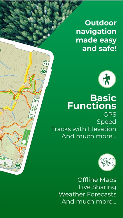
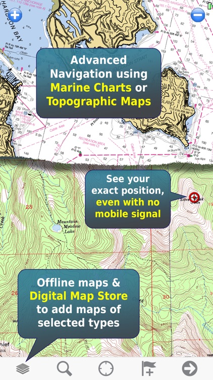
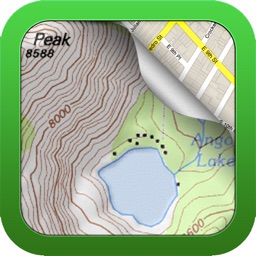
MapToaster for iOS provides New Zealand topo maps with all the rich detail of the LINZ Topo50 and Topo250 topographical maps, helping you plan your expedition and get to the right spot. Whether you are a recreational or business user, MapToaster provides indispensable reference topo maps, with easy-to-use software.

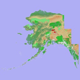
The app includes a 1:250,000 scale topographical map of New Zealand.

The 1:50,000 scale topo maps are available for in-app purchase and these include:

* New Zealand South Islandand Stewart Island
* New Zealand North Island, Kermadec group and Chatham Islands
* Antarctica around the area of the Ross Sea and the sub-antarctic islands - Antipodes Is, Auckland Is, Bounty Is, Campbell Is, Snares Is

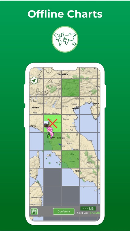
Once downloaded, the mapping doesn't need a WiFi connection or cellphone coverage, as the maps are stored on your device.

Features:
* detailed LINZ 1:50,000 mapping available by in-app purchase.
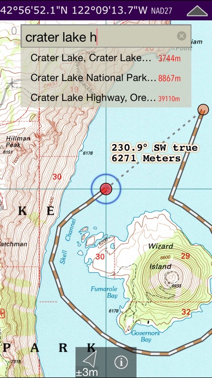
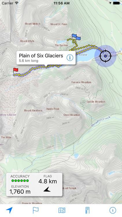
* comprehensive search index with over 60,000 placenames. Includes all the map placenames, locality names, track start and end points
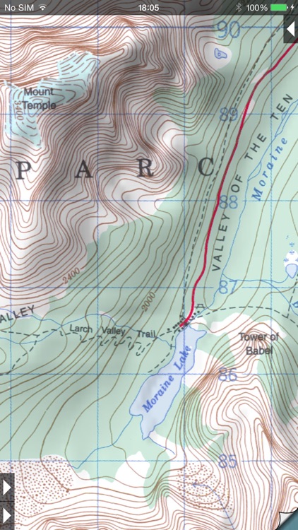
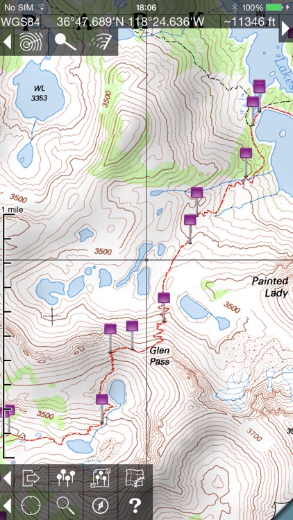
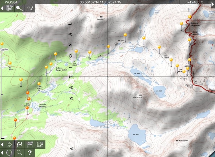
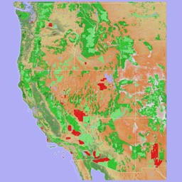
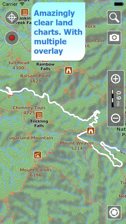
* 1:50,000 mapping shows Conservation Estate with a magenta border and Scenic & Recreation reserves with a red border
* built-in map legend
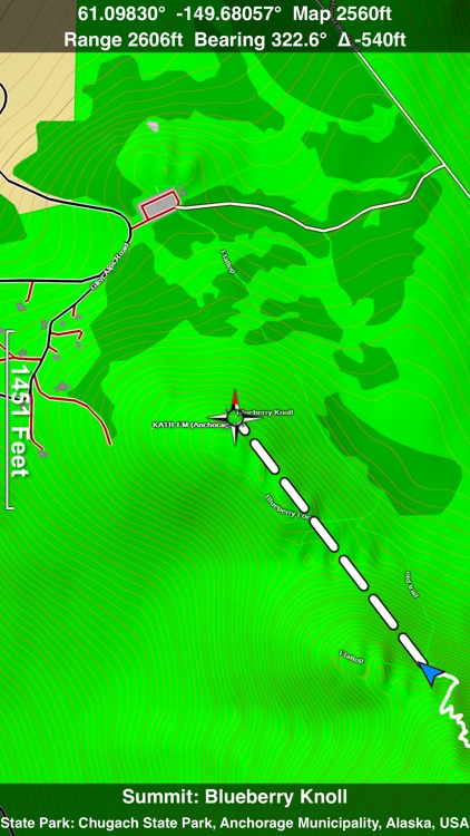
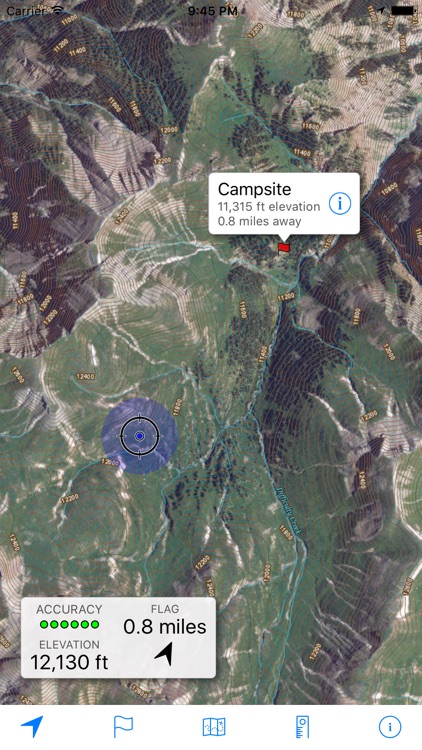
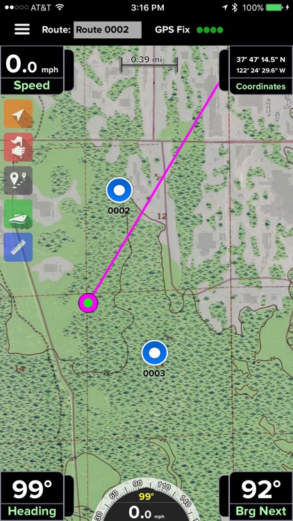
* coordinates can be displayed and entered either in WGS-84 longitude/latitude or local projected coordinates (e.g. NZTM etc)
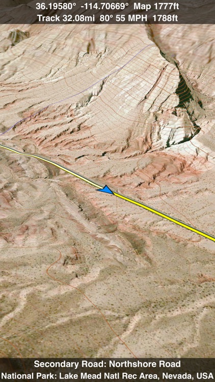
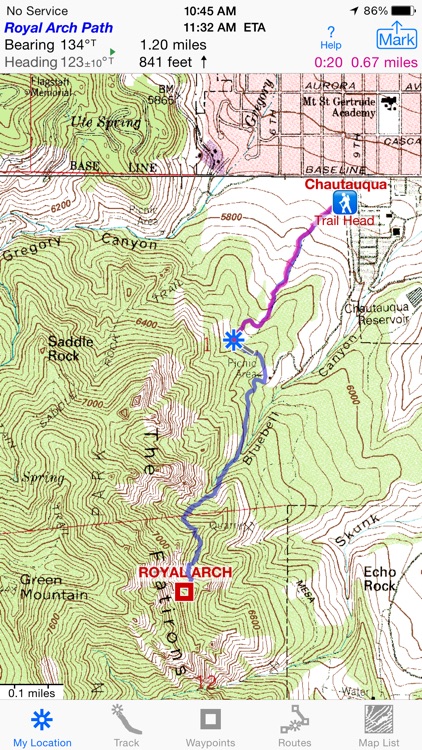
* navigate to a waypoint using a head-up display on the map. Shows the speed, time-to-destination, distance, bearing and direction to turn to get to the destination. Select a destination by tapping the waypoint symbol on the map, then the "Navigate to Waypoint" menu option. Tap the navigation display to cancel navigation. Option to use device heading or ground track for direction.
* share waypoints by email, iMessage and AirDrop
* import waypoints from GPX files by email, iMessage and AirDrop
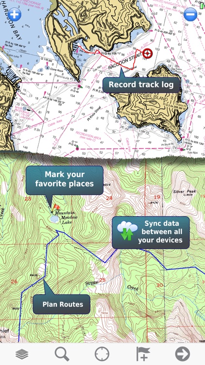
* import and share tracks in GPX file format by email, iMessage and AirDrop
* geocachers can view the full detail in geocaching.com PocketQuery files, with automatic colour coding by cache type.
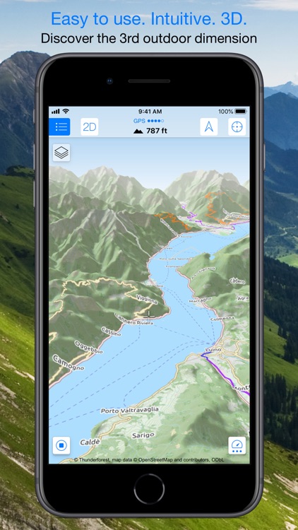
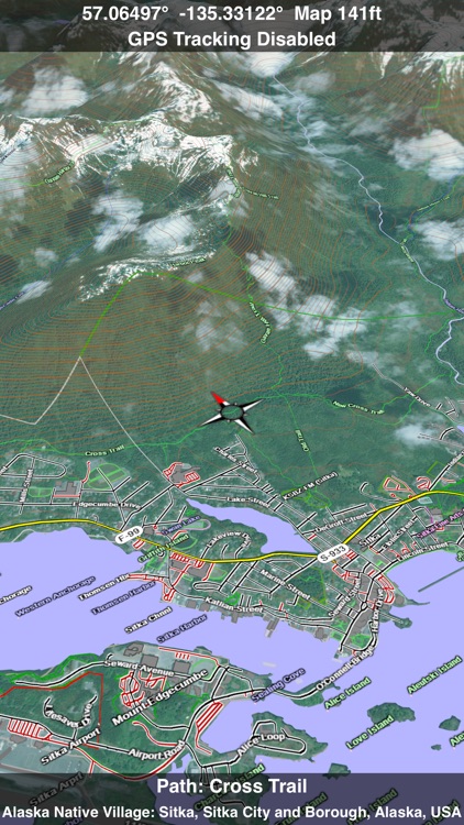
* map can show and follow your current location. Map display can be north-up or track-up
* create waypoints either at your current location or by tap & hold on the map
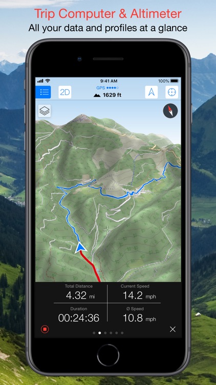
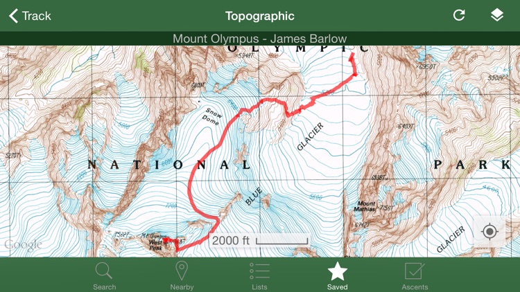
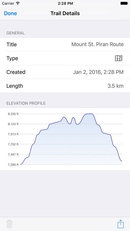
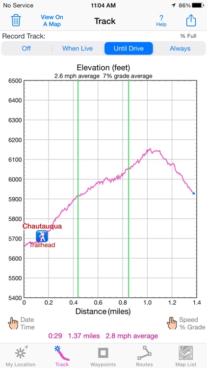
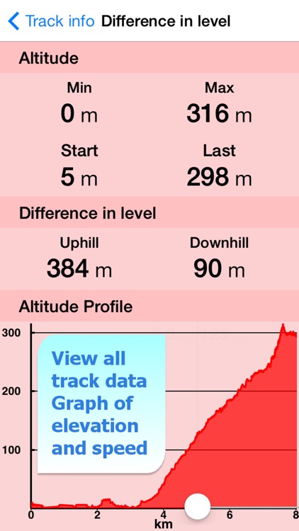
* create a track by tapping out a path on the screen
* record your track while the GPS is running. Note that continued use of GPS running in the background can dramatically decrease battery life.
* split screen mode for iPads
* 3D Touch Home screen shortcuts on iPhone 6s or later
* map browsing and Find handoff between your devices. View a map on your iPhone and jump to your iPad at the same place
* the Find, Track and Waypoint views show the distance from the centre of the current view
* measure distances by tapping out a track on the screen
* uses familar gestures: pinch to zoom, drag, double-tap to zoom in, two-finger tap to zoom out, tap & hold to mark a waypoint
* maps are stored on your device. Once the download is done, you don't need an Internet connection
* privacy-friendly. The app doesn't report your location to us and the waypoints & tracks stay on your device, unless you choose to share them
* friendly helpful technical support by email

Made by Integrated Mapping Ltd, a Christchurch-based company with over 30 years experience in developing mapping software, whose customers include multinational consulting companies, conservation organisations, Crown Research Institutes, central, regional and local government, universities, schools and libraries, emergency services such as St Johns, helicopter rescue, Search and Rescue, and Police.

Scenic Map Eastern Canada

Scenic Map Eastern Canada

GrangerFX

A 3D topo map of Eastern Canada. The vector map data is downloaded and can then used without an internet connection. Use it in a car, a boat, a plane or while hiking. It is like having more than a third of the country in your pocket.

Scenic Map now covers the entire world via online maps. The maps are cached automatically so they can still be used when there is no cell coverage. Turn on Online Map in the Settings menu and you can then scroll or go to any location on the planet. Satellite image overlays add breathtaking detail and realism to the maps (tap preset 2 or 4 when Online Map is enabled). You can use them as you travel to see what is hidden from view at ground level. This takes moving maps to a whole new level.

Use the two finger vertical swipe gesture to tilt the map for a 3D view. Scroll like a map or fly like a flight simulator. Enable Joystick Gestures in the Settings menu and then fly around the terrain using a virtual joystick. Prefer only 2D maps? Enable the 2D Map option in the Settings menu.

Scenic Map is simply the best 3D topo map available for a mobile device. You will see incredible detail while scrolling, rotating and zooming perfectly smoothly. You will see every road even if you zoom out to the altitude of a satellite. As you zoom in, you will see every small bump and hollow of the Earth and terrain features as small as ten meters. Unlike old fashioned topo maps, Scenic Map’s roads and trails are up to date thanks to OpenStreetMap.org. It contains polygons for urban areas, shopping malls, an ever growing number of buildings and many other features, The best lake, pond, stream and rivers from the USGS and Canadian public databases are also included.

Tap the GPS center button to begin tracking your location. As you move, you will generate a track file. Tracks can be replayed with video like controls to speed up, slow down, pause, restart or skip to the end. You can display existing tracks while recording another if you want to retrace your route. When online, you can automatically create a route from your current GPS location to any other point on the map. Tracks can be received from or sent to other apps in GPX format. GPS recording stops automatically after you have remained stationary for some time or you can choose to manually stop tracking by tapping on the top track in the Tracks view.

Never before have maps been this customizable. For example, you can turn on or off the roads. You can change the lighting direction or remove terrain shading entirely. You can display contour lines even over satellite images. There are five presets which let you quickly switch between map styles. Use Metric, English or Nautical units and choose one of four different coordinate displays including UTM.

Want to learn more about a map feature? Tap the target icon and center the feature under the compass rose to display its name, type, urban area, county, state, elevation and coordinates. You will also see a bearing line back to your current GPS location or from your location to a selected waypoint. The status bar shows the bearing direction and distance along with the map and GPS elevation, the track length, and your current speed and direction of travel.

In-app documentation is provided in the Help section at the top of the Settings menu. Links are provided in the documentation to detailed coverage maps, tutorial videos, installation guide and blog at ScenicMap.com
Map data © OpenStreetMap and contributors under the Open Database License

Scenic Map supports GPS tracking while the app is in the background.
Caution: Continued use of GPS running in the background can dramatically decrease battery life.

Scenic Map Western Canada

Scenic Map Western Canada

GrangerFX

A 3D topo map of Western Canada. All map data is dowloaded to your device and can then be used without an internet connection. Use it in a car, a boat, a plane or while hiking. It is like having more than a third of the country in your pocket.

Scenic Map now covers the entire world via online maps. The maps are cached automatically so they can still be used when there is no cell coverage. Turn on Online Map in the Settings menu and you can then scroll or go to any location on the planet. Satellite image overlays add breathtaking detail and realism to the maps (tap preset 2 or 4 when Online Map is enabled). You can use them as you travel to see what is hidden from view at ground level. This takes moving maps to a whole new level.

Use the two finger vertical swipe gesture to tilt the map for a 3D view. Scroll like a map or fly like a flight simulator. Enable Joystick Gestures in the Settings menu and then fly around the terrain using a virtual joystick. Prefer only 2D maps? Enable the 2D Map option in the Settings menu.

Scenic Map is simply the best 3D topo map available for a mobile device. You will see incredible detail while scrolling, rotating and zooming perfectly smoothly. You will see every road even if you zoom out to the altitude of a satellite. As you zoom in, you will see every small bump and hollow of the Earth and terrain features as small as ten meters. Unlike old fashioned topo maps, Scenic Map’s roads and trails are up to date thanks to OpenStreetMap.org. It contains polygons for urban areas, shopping malls, an ever growing number of buildings and many other features, The best lake, pond, stream and rivers from the USGS and Canadian public databases are also included.

Tap the GPS center button to begin tracking your location. As you move, you will generate a track file. Tracks can be replayed with video like controls to speed up, slow down, pause, restart or skip to the end. You can display existing tracks while recording another if you want to retrace your route. When online, you can automatically create a route from your current GPS location to any other point on the map. Tracks can be received from or sent to other apps in GPX format. GPS recording stops automatically after you have remained stationary for some time or you can choose to manually stop tracking by tapping on the top track in the Tracks view.

Never before have maps been this customizable. For example, you can turn on or off the roads. You can change the lighting direction or remove terrain shading entirely. You can display contour lines even over satellite images. There are five presets which let you quickly switch between map styles. Use Metric, English or Nautical units and choose one of four different coordinate displays including UTM.

Want to learn more about a map feature? Tap the target icon and center the feature under the compass rose to display its name, type, urban area, county, state, elevation and coordinates. You will also see a bearing line back to your current GPS location or from your location to a selected waypoint. The status bar shows the bearing direction and distance along with the map and GPS elevation, the track length, and your current speed and direction of travel.

In-app documentation is provided in the Help section at the top of the Settings menu. Links are provided in the documentation to detailed coverage maps, tutorial videos, installation guide and blog at ScenicMap.com
Map data © OpenStreetMap and contributors under the Open Database License

Scenic Map supports GPS tracking while the app is in the background.
Caution: Continued use of GPS running in the background can dramatically decrease battery life.

Scenic Map Central Canada

Scenic Map Central Canada

GrangerFX

A 3D topo map of Central Canada. The vector map data is downloaded and can then used without an internet connection. Use it in a car, a boat, a plane or while hiking. It is like having more than a third of the country in your pocket.

Scenic Map now covers the entire world via online maps. The maps are cached automatically so they can still be used when there is no cell coverage. Turn on Online Map in the Settings menu and you can then scroll or go to any location on the planet. Satellite image overlays add breathtaking detail and realism to the maps (tap preset 2 or 4 when Online Map is enabled). You can use them as you travel to see what is hidden from view at ground level. This takes moving maps to a whole new level.

Use the two finger vertical swipe gesture to tilt the map for a 3D view. Scroll like a map or fly like a flight simulator. Enable Joystick Gestures in the Settings menu and then fly around the terrain using a virtual joystick. Prefer only 2D maps? Enable the 2D Map option in the Settings menu.

Scenic Map is simply the best 3D topo map available for a mobile device. You will see incredible detail while scrolling, rotating and zooming perfectly smoothly. You will see every road even if you zoom out to the altitude of a satellite. As you zoom in, you will see every small bump and hollow of the Earth and terrain features as small as ten meters. Unlike old fashioned topo maps, Scenic Map’s roads and trails are up to date thanks to OpenStreetMap.org. It contains polygons for urban areas, shopping malls, an ever growing number of buildings and many other features, The best lake, pond, stream and rivers from the USGS and Canadian public databases are also included.

Tap the GPS center button to begin tracking your location. As you move, you will generate a track file. Tracks can be replayed with video like controls to speed up, slow down, pause, restart or skip to the end. You can display existing tracks while recording another if you want to retrace your route. When online, you can automatically create a route from your current GPS location to any other point on the map. Tracks can be received from or sent to other apps in GPX format. GPS recording stops automatically after you have remained stationary for some time or you can choose to manually stop tracking by tapping on the top track in the Tracks view.

Never before have maps been this customizable. For example, you can turn on or off the roads. You can change the lighting direction or remove terrain shading entirely. You can display contour lines even over satellite images. There are five presets which let you quickly switch between map styles. Use Metric, English or Nautical units and choose one of four different coordinate displays including UTM.

Want to learn more about a map feature? Tap the target icon and center the feature under the compass rose to display its name, type, urban area, county, state, elevation and coordinates. You will also see a bearing line back to your current GPS location or from your location to a selected waypoint. The status bar shows the bearing direction and distance along with the map and GPS elevation, the track length, and your current speed and direction of travel.

In-app documentation is provided in the Help section at the top of the Settings menu. Links are provided in the documentation to detailed coverage maps, tutorial videos, installation guide and blog at ScenicMap.com
Map data © OpenStreetMap and contributors under the Open Database License

Scenic Map supports GPS tracking while the app is in the background.
Caution: Continued use of GPS running in the background can dramatically decrease battery life.

GPS Topo USA

GPS Topo USA

Gogal Publishing Company

GPS Topo USA turns your iPhone or iPad into a fully functional GPS. It features seamless 1:24,000 scale, USGS topographic maps that store locally for offline use.

Waypoints allow you to create, store, annotate and display your own custom destinations on the map. Use waypoints to store tree stands, fishing spots, duck blinds, trail heads, or any other point of interest. Get turn-by-turn driving directions or use the app's built in field compass to guide you right to any waypoint. Store your vehicle's location so you can return from the wild's with confidence.

Each waypoint features a "GO" button for turn-by-turn driving directions and a "Target" button for compass navigation. Simply follow the direction of travel arrow on your compass and let you're guided to your targeted destination.

In addition to topographic maps, you can also choose and of Apple's Road Maps, Satellite Images, or Hybrid Maps while online and we've included a road map that stores locally for offline use from the OpenStreetMap project.

For your safety, GPS Topo USA is intended only as a reference and should not be used as your sole means of navigation.

Note: WiFi only iPads may not include a GPS receiver which is required for navigation in the field.

mAPP - Offline Mapping App

mAPP - Offline Mapping App

Looking4Cache UG (haftungsbeschraenkt)

mAPP is right for everyone how needs offline mapping on iOS. Download OSM vector maps on your device and use it in dead spots or in other countries without roaming costs.

Pure mapping:
Pure offline maps in a clear surface. No bells and whistles, no social, no restaurant suggestions. Just orientation! Ideal for hobby and travel.

Offline topo maps:
Load whole countries or states and view them later without internet connection. The maps includes full OSM detail down to small pathways. As well contour lines included in the topo maps.

Tracks:
Record tracks and store them on the device or share them as a gpx file. You can also import gpx tracks provided by several platforms for hiking and cycling and display them on the map. Tracks from GPSies, the maybe largest collection on the web, can be downloaded directly within this app.

Waypoints:
Enter waypoints to mark a location. So you can use mAPP also for hobbies like geocaching. Use the link options in other apps like Looking4Cache or Geosphere to share waypoints.

Multiplans

Multiplans

Vincent Ballenegger

Do you have maps that you would like to use offline on your iPhone/iPad with GPS positioning? Discover Multiplans, a powerful map application in which you can import your maps (whatever their source) and view them offline with a great multitouch experience and pinpoint accurate GPS positioning. Multiplans can moreover record tracks and save points of interests.

Multiplans has been designed to offer a great map viewing experience: simple uncluttered interface, map shown full screen (a single tap toggles on/off the display of overlay information), ultra-fast scrolling and zooming.

With Multiplans, you don't have to buy again maps that you already own, just to use them on your iPhone. No subscription either that will soon expire. To use a map on your iPhone/iPad, simply transfer the map image into Multiplans (with a .map or ref.txt calibration file if you have one). Maps can be also calibrated entirely within Multiplans by defining graphically calibration points on the map.

A few sample maps are provided with Multiplans: a world map, a map of Switzerland, etc. A few more maps can be downloaded free of charge from www.multiplans.net. Multiplans is compatible with almost all coordinate systems used in the world. To import your own maps into Multiplans and have accurate GPS positioning, the map needs to be calibrated (see www.multiplans.net). Maps from OpenStreetMap (for any region in the world), as well as maps from similar mapping web sites, can be imported into Multiplans very easily by using the free program mobile atlas creator.

Visit www.multiplans.net for more information.

IMPORTANT NOTES:
- Continued use of the GPS running in the background can dramatically reduce battery life on the iPhone or iPad.
- Multiplans' features, including map and location accuracy, should not be depended upon in situations where inaccuracies or errors could cause danger, commercial loss or any other problem. Though we did our best to make Multiplans an excellent app, it is provided as is with no warranty.

MotionX GPS HD

MotionX GPS HD

Fullpower®

#1 "Provides all the tools you’ll ever need, anywhere in the world." -iPadModo

#1 "Recommended for people looking for a do-it-all navigation app that covers land, air and sea." -Navigadget

#1 "MotionX-GPS HD iPad app looks even better than the iPhone version." -Gizmodo

▶ The #1 multi-sport application for the iPad

▶ MotionX-GPS HD has all the Maps and Navigation Instruments you need for your outdoor life: hiking, walking, sailing, off-roading, flying, geocaching, hunting, fishing or exploring, anywhere in the world. MotionX-GPS HD works on a hike, on a boat, in a plane, visiting a new city, or just browsing the globe from home.

▶ Free downloadable maps worldwide! Including OpenStreetMap, terrain maps, and NOAA marine charts

▶ Over 5 million users, top rated around the world

▶ MOST ACCURATE IPAD GPS!

▶ BEST MAP SELECTION! Choose from 14 different sources including road, terrain / topo, satellite, and marine map types

▶ MAP STORAGE ONBOARD! Unlimited downloading of maps for use offline

▶ 300 TRACKS & 2500 WAYPOINTS!

▶ LIVE POSITION UPDATES: optionally share your position automatically in real-time with others you choose

▶ ADVANCED INTERACTIVE STOPWATCH WITH LIVE VOICE COACHING

▶ Supports DMS, DM, D, MGRS, UTM, and OSGB grid systems

▶ Import and export GPX files

Continued use of any GPS service running in the background can significantly decrease battery life.

MotionX is committed to constant improvement. We listen to our users and continuously add the most requested features. Thank you for the feedback!

Singletracks Topo

Singletracks Topo

Blue Spruce Ventures

The Singletracks app gives you access to thousands of mountain bike trails, gear reviews, maps, articles, and photos on the go.

- Find the closest mountain bike trails to your current location.
- Read trail reviews, view photos, and even follow topo maps of select trails.
- Add trail reviews and photos directly from the app. Check in and update trail status.
- Get turn-by-turn directions to trailheads from your location or any address.
- Keep track of your trail and gear lists and wishlists.
- Find nearby bike shops and read reviews. Add shop reviews and photos from the app.
- View and comment on the photo of the day.
- Optimized for fast data downloads in the field. Looks great on the iPad too.

New trails, photos, and reviews are constantly updated so you'll always have the latest info.

Note: Continued use of GPS running in the background can dramatically decrease battery life.